sales@allshipparts.com +86-18901613703
ICOM CLASS B AIS TRANSPONDER MA-510TR,ICOM,CLASS B AIS TRANSPONDER,MA-510TR
ICOM CLASS B AIS TRANSPONDER MA-510TR
Contact: Lily Zhang
E-mail:sales@allshipparts.com
E-mail:info@allshipparts.com
WeChat:Allshipparts
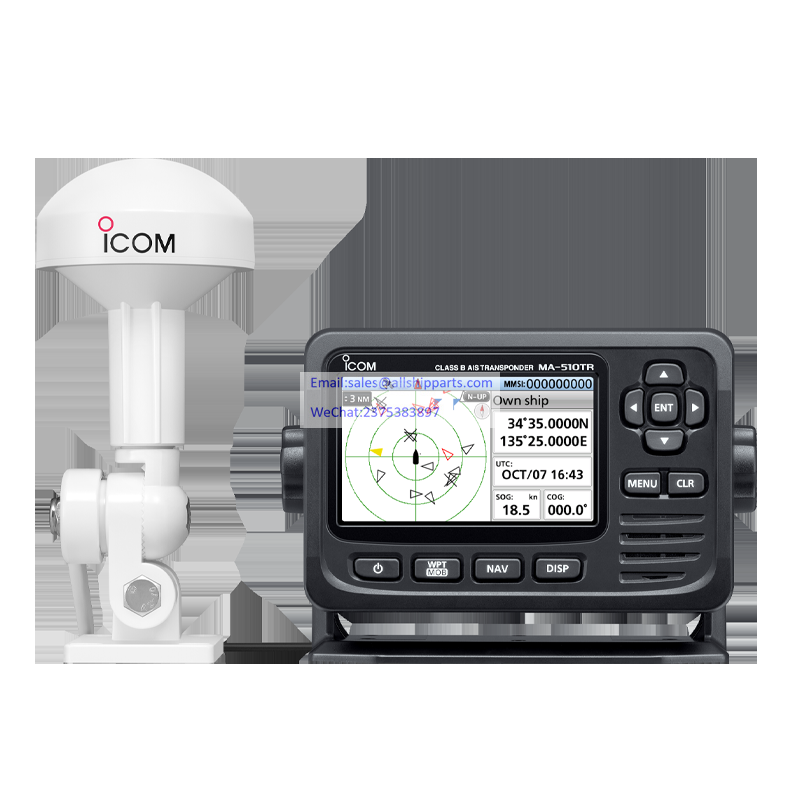
An AIS transponder on your boat automatically receives information broadcast by other AIS-equipped vessel’s and base stations, all while your own vessel’s static and dynamic information is being transmitted. Using with an AIS transponder, you can find AIS mounted small boats and buoys that are difficult to be detected with a marine radar. The MA-510TR can receive both Class A and B AIS signals and increases your safety at sea.
SHAPE \* MERGEFORMAT
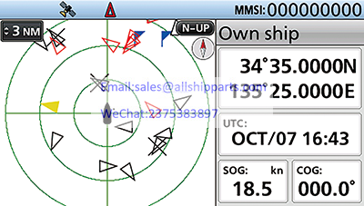
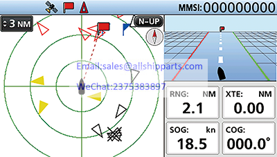
Plotter screen (Day mode)
The wide viewing, high resolution 4.3-inch color TFT display clearly shows your and other vessels’ positions. Potentially dangerous vessels are shown in red and ships registered as your friends are shown in yellow. The day-mode display is readable in direct sunlight, and the night-mode display ensures good readability in the dark for further convenience.
SHAPE \* MERGEFORMAT
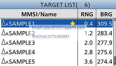
Target list screen
The ‘Target’ list screen shows all detected AIS equipped vessels and targets. The ‘Danger’ list screen shows a list of vessels that are within six nautical miles of Closest Point of Approach (CPA) and sixty minutes of Time to Closest Point of Approach (TCPA) from your vessel. The ‘Friend’ list screen displays the detected AIS targets that you set as friends. When you want to see target details, select the target by the cursor keys and push [ENT] key.
SHAPE \* MERGEFORMAT
Detail screen examples
SHAPE \* MERGEFORMAT
Plotter screen with Navigation screen
The Navigation function guides you to a specified waypoint or AIS target. You can assign a maximum of 100 favorite fishing spots or destinations as waypoints. The Navigation function is simply started by just selecting a waypoint or an AIS target on the display.
SHAPE \* MERGEFORMAT
Navigation screen
SHAPE \* MERGEFORMAT
Plotter screen with MOB Navigation screen
When the [WPT/MOB] button is held down, the MA-510TR automatically marks a waypoint of the vessel’s current position and activates the MOB (Man Overboard) navigation function to the location the MOB event occurred.
SHAPE \* MERGEFORMAT
MOB Navigation screen
You can transmit an individual DSC Call by simply selecting an
AIS target and the voice channel on the MA-510TR*.
* A compatible Icom VHF radio is required. The MA-510TR and a
radio can be connected with the accessory cable. See the instruction manual of
each for radio’s connecting instructions.
AIS data can be output from an USB cable connector on the rear
panel*.
* A third party application and a connection cable are required.
SHAPE \* MERGEFORMAT
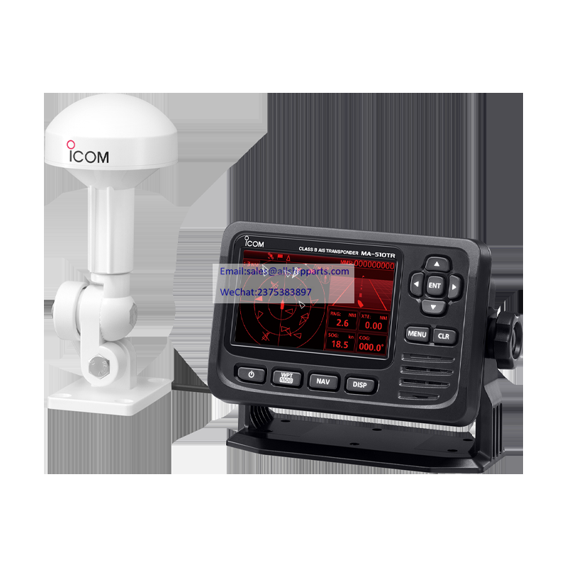
Supplied GPS antenna
The GPS receiver with SBAS function is integrated in the MA-510TR. Position information can be simply received with connection to the supplied GPS antenna with 10 m, 32.8 ft cable.
With the plug-and-play functionality of NMEA 2000™, the MA-510TR can connect to a NMEA 2000™ network (an external plotter, marine radar and VHF radio). Using NMEA 0183/-HS connectivity, the transponder can connect to a transceiver, plotter device, marine radar, external GPS receiver, or switch button.
When a vessel comes into the CPA or TCPA range, the vessel’s icon blinks on the plotter display and a beep sound is heard. When connected to external audio equipment installed on the chart table or fly bridge, the collision alarm function will alert you, even when you are away from the AIS transponder.
Silent mode switches off the AIS transmitter and allows you to temporarily stop transmitting your vessel’s position information. This function is useful when you do not want to reveal your fishing spots to other vessels. You can receive other vessel’s AIS reports also while the silent mode is ON.
· Compatible with both 12 V and 24 V power sources
· Multi-lingual user interface (English, French, Indonesian, Spanish and Vietnamese)
· Anchor watch function sounds an alarm when your vessel is at anchor but has drifted
· IPX7 waterproof protection (up to 1 m depth of water for 30 minutes; except connectors)
|
Operating frequencies |
161.500 MHz to 162.025 MHz |
|
|
Type of emission |
16K0GXW (GMSK) |
|
|
Antenna impedance |
50 Ω nominal |
|
|
Intermediate frequency |
CH-A |
1st: 21.700 MHz, 2nd: 450 kHz |
|
CH-B |
1st: 30.150 MHz, 2nd: 450 kHz |
|
|
Operating temperature range |
–20°C
to +60°C; |
|
|
Power supply requirement |
Negative ground: 12 V or 24 V DC nominal (9.6 to 31.2 V) |
|
|
Current drain (at 12 V DC) |
TX: 1.5 A, RX: 0.7 A |
|
|
Dimensions (approximate)) |
166.2
(W) × 110.2 (H) × 92.5 (D) mm, |
|
|
Weight (approximate)) |
700 g, 1.5 lb |
|
|
Output power |
2 W |
|
Modulation |
16K0GXW (GMSK) |
|
Conducted spurious emission |
Less
than –36 dBm (9 kHz–1 GHz) |
|
Sensitivity |
Less than –110 dBm |
|
Adjacent channel selectivity |
More than –31 dBm |
|
Spurious response |
More than –31 dBm |
|
Intermodulation |
More than –36 dBm |
|
Conducted spurious emission |
Less
than –57 dBm (9 kHz–1 GHz) |
|
Blocking |
More
than –23 dBm (±0.5 MHz–±5 MHz) |
|
Co-channel |
More than –111 dBm |
|
Frequency coverage |
156.525 MHz |
|
Type of emission |
16K0G2B |
|
Sensitivity |
Less than –110 dBm |
|
Adjacent channel selectivity |
More than 70 dB |
|
Spurious response |
More than –34 dBm |
|
Intermodulation |
More than –39 dBm |
|
Blocking |
More than –20 dBm |
|
Received frequency |
1575.42 MHz |
|
Acquisition |
72 ch (maximum) |
|
Differential satellites |
WAAS, EGNOS, MSAS, GAGAN |
|
Dimensions (approximate) |
96.2 × 225 (H) mm, 3.8 × 8.9 (H) inch |
|
Weight (approximate) |
700 g, 1.5 lb (including cable and mounting bracket) |
|
Cable length (approximate) |
10 m, 32.8 ft |
|
USB (Type-B Mini) |
GGA, GNS, GLL, GSA, GSV, RMC, VTG, VDM, VDO, ACA, ACS, ALR, TXT |
|
|
NMEA 2000TM |
Input |
059392/904, 060160/416/928, 065240, 126208/996, 129026/029/545 |
|
Output |
059392/904, 060416/928, 126208/464/993/996/998, 129026/029/038/039/040/041/539/540/545/792/793/794/797/798/801/802/803/805/806/807/809/810/811 |
|
|
NMEA 0183 |
NMEA Input/Output |
4800–38400
bps Input/Output, |
|
External GPS Input |
4800–38400
bps Input, |
|
|
AIS Output |
38400
bps Output, |
|
*1 Only 38400 bps. *2 When a received GPS signal does not include a GBS sentence, the transponder will not receive the signal from the external GPS receiver.
SHAPE \* MERGEFORMAT
All stated specifications are subject to change without notice or obligation.
IC-M605, IC-M605EURO, IC-M506, IC-M506EURO, IC-M506GE, IC-M424, IC-M424G, IC-M423, IC-M423G, IC-M423GE, IC-M400BB, IC-M400BBE, IC-M330, IC-M330G, IC-M330GE, IC-M324, IC-M324G, IC-M323, IC-M323G
* As of May 2020
· GPS antenna
· DC power cable
· Mounting bracket kit
· Accessory connector
SART,AIS SART,AIS-SART
JRCS,Discontinued,SMS-22-K,SMS-55
JRCS Important Notice of Discontinuation of Prod
Contact: Jack Zhang
Phone: +86-18901613703
Tel: +86-18901613703
Email: sales@allshipparts.com
Add: Unit 188, Building 19, No. 218 Huting North Road, Songjiang District, Shanghai